Home Page
parcel background

Platform

Indispensable parcel management tools for county and city governments

Upgrade your workflows with a centralized, digital solution for appraisals, appeals, sales searches, forms, and much more.

Request a Demo
A digital map with outlined property parcels and data overlays, held over a aerial view of a rural area.
abstract

Before Schneider

Path Siloed systems
Path Manually complying assessments data
Path High volume of in-office visits
Path Struggling to keep up with citizen demand for 24/7 digital government
Path Time intensive appeals processes

After Schneider

Checkmark icon Systems that integrate with CAMA, Tax Administration, more
Checkmark icon Easily and accurately analyze property values
Checkmark icon Simplify daily tasks + reduce in-office visits
Checkmark icon Provide modern tools for citizen engagement
Integrate​​​​‌‍​‍​‍‌‍‌​‍‌‍‍‌‌‍‌‌‍‍‌‌‍‍​‍​‍​‍‍​‍​‍‌​‌‍​‌‌‍‍‌‍‍‌‌‌​‌‍‌​‍‍‌‍‍‌‌‍​‍​‍​‍​​‍​‍‌‍‍​‌​‍‌‍‌‌‌‍‌‍​‍​‍​‍‍​‍​‍‌‍‍​‌‌​‌‌​‌​​​‍‍​‍​‍‌‍​‌‍‌‍​‌‍​‌‌‍​‌‍‍​‌‍‌​‌‌​​‍‍​​​​​​​​​‍‌‍‍‌‌‍‍‌‌​‌‍‌‌‌‍‍‌‌​​‍‌‍‌‌‌‍‌​‌‍‍‌‌‌​​‍‌‍‌‌‍‌‍‌​‌‍‌‌​‌‌​​‌​‍‌‍‌‌‌​‌‍‌‌‌‍‍‌‌​‌‍​‌‌‌​‌‍‍‌‌‍‌‍‍​‍‌‍‍‌‌‍‌​​‌‌​​‌‍​‌‌​‍‌‍​‌‍‌‌‌‍​‌‌​​‌‍​‌‌‍‌‌‍‌‌​‍‌‌​‌‍‌‌​​‌‍‌‌​‌‌​​‌‍​‌‌​‍‌‍​‌‍‌‌‌‍​‌‌​​‌‍​‌‌‍‌‌‍‌‌​‍‌​​‌‍​‌‌‌​‌‍‍​​‌‌​‌‍‌‍​‌‌‌‌‌​‌‍‍‌‌‍‌‍‍‌‌​‌‍‌‌‌‍​‌‌​‌‍‍‌‌‍‌‍‍‌​​‍‌‌​‌‌‌​​‍‌‌‌‍‍‌‍‌‌‌‍‌​‍‌‌​​‌​‌​​‍‌‌​​‌​‌​​‍‌‌​​‍​​‍‌‍​‍‌‍‌‍​‍‌‌‍​‌‍‌​​‍​​​‍‌‍‌​​‌‍​‌‌‌‍​​‌‍​‍‌‌​​‍​​‍​‍‌‌​‌‌‌​‌​​‍‍‌‌​‌‍‍‌‌‌​‌‍​‌‍‌‌​‌‍​‍‌‍​‌‌​‌‍‌‌‌‌‌‌‌​‍‌‍​​‌‌‍‍​‌‌​‌‌​‌​​​‍‌‌​​‌​​‌​‍‌‌​​‍‌​‌‍​‍‌‌​​‍‌​‌‍‌‍​‌‍‌‍​‌‍​‌‌‍​‌‍‍​‌‍‌​‌‌​​‍‌‌​​‌​​‌​​​​​​​​​‍‌‍‌‍‍‌‌‍‌​​‌‌​​‌‍​‌‌​‍‌‍​‌‍‌‌‌‍​‌‌​​‌‍​‌‌‍‌‌‍‌‌​‍‌‍‌‌​‌‍‌‌​​‌‍‌‌​‌‌​​‌‍​‌‌​‍‌‍​‌‍‌‌‌‍​‌‌​​‌‍​‌‌‍‌‌‍‌‌​‍‌‍‌​​‌‍​‌‌‌​‌‍‍​​‌‌​‌‍‌‍​‌‌‌‌‌​‌‍‍‌‌‍‌‍‍‌‌​‌‍‌‌‌‍​‌‌​‌‍‍‌‌‍‌‍‍‌​​‍‌‌​‌‌‌​​‍‌‌‌‍‍‌‍‌‌‌‍‌​‍‌‌​​‌​‌​​‍‌‌​​‌​‌​​‍‌‌​​‍​​‍‌‍​‍‌‍‌‍​‍‌‌‍​‌‍‌​​‍​​​‍‌‍‌​​‌‍​‌‌‌‍​​‌‍​‍‌‌​​‍​​‍​‍‌‌​‌‌‌​‌​​‍‍‌‌​‌‍‍‌‌‌​‌‍​‌‍‌‌​‍​‍‌‌

POWERFULLY UNIFIED INFORMATION​​​​‌‍​‍​‍‌‍‌​‍‌‍‍‌‌‍‌‌‍‍‌‌‍‍​‍​‍​‍‍​‍​‍‌​‌‍​‌‌‍‍‌‍‍‌‌‌​‌‍‌​‍‍‌‍‍‌‌‍​‍​‍​‍​​‍​‍‌‍‍​‌​‍‌‍‌‌‌‍‌‍​‍​‍​‍‍​‍​‍‌‍‍​‌‌​‌‌​‌​​​‍‍​‍​‍‌‍​‌‍‌‍​‌‍​‌‌‍​‌‍‍​‌‍‌​‌‌​​‍‍​​​​​​​​​‍‌‍‍‌‌‍‍‌‌​‌‍‌‌‌‍‍‌‌​​‍‌‍‌‌‌‍‌​‌‍‍‌‌‌​​‍‌‍‌‌‍‌‍‌​‌‍‌‌​‌‌​​‌​‍‌‍‌‌‌​‌‍‌‌‌‍‍‌‌​‌‍​‌‌‌​‌‍‍‌‌‍‌‍‍​‍‌‍‍‌‌‍‌​​‌‌​​‌‍​‌‌​‍‌‍​‌‍‌‌‌‍​‌‌​​‌‍​‌‌‍‌‌‍‌‌​‍‌‌​‌‍‌‌​​‌‍‌‌​‌‌​​‌‍​‌‌​‍‌‍​‌‍‌‌‌‍​‌‌​​‌‍​‌‌‍‌‌‍‌‌​‍‌​​‌‍​‌‌‌​‌‍‍​​‌‌​‌‍‌‍​‌‌‌‌‌​‌‍‍‌‌‍‌‍‍‌‌​‌‍‌‌‌‍​‌‌​‌‍‍‌‌‍‌‍‍‌​​‍‌‌​‌‌‌​​‍‌‌‌‍‍‌‍‌‌‌‍‌​‍‌‌​​‌​‌​​‍‌‌​​‌​‌​​‍‌‌​​‍​​‍‌‍​‍‌‍‌‍​‍‌‌‍​‌‍‌​​‍​​​‍‌‍‌​​‌‍​‌‌‌‍​​‌‍​‍‌‌​​‍​​‍​‍‌‌​‌‌‌​‌​​‍‍‌‌​‌‍​‌‌‍‌‌‌​‌‍‍‌‌‌​‌‍​‌‍‌‌​‌‍​‍‌‍​‌‌​‌‍‌‌‌‌‌‌‌​‍‌‍​​‌‌‍‍​‌‌​‌‌​‌​​​‍‌‌​​‌​​‌​‍‌‌​​‍‌​‌‍​‍‌‌​​‍‌​‌‍‌‍​‌‍‌‍​‌‍​‌‌‍​‌‍‍​‌‍‌​‌‌​​‍‌‌​​‌​​‌​​​​​​​​​‍‌‍‌‍‍‌‌‍‌​​‌‌​​‌‍​‌‌​‍‌‍​‌‍‌‌‌‍​‌‌​​‌‍​‌‌‍‌‌‍‌‌​‍‌‍‌‌​‌‍‌‌​​‌‍‌‌​‌‌​​‌‍​‌‌​‍‌‍​‌‍‌‌‌‍​‌‌​​‌‍​‌‌‍‌‌‍‌‌​‍‌‍‌​​‌‍​‌‌‌​‌‍‍​​‌‌​‌‍‌‍​‌‌‌‌‌​‌‍‍‌‌‍‌‍‍‌‌​‌‍‌‌‌‍​‌‌​‌‍‍‌‌‍‌‍‍‌​​‍‌‌​‌‌‌​​‍‌‌‌‍‍‌‍‌‌‌‍‌​‍‌‌​​‌​‌​​‍‌‌​​‌​‌​​‍‌‌​​‍​​‍‌‍​‍‌‍‌‍​‍‌‌‍​‌‍‌​​‍​​​‍‌‍‌​​‌‍​‌‌‌‍​​‌‍​‍‌‌​​‍​​‍​‍‌‌​‌‌‌​‌​​‍‍‌‌​‌‍​‌‌‍‌‌‌​‌‍‍‌‌‌​‌‍​‌‍‌‌​‍​‍‌‌

Seamlessly Compile and Analyze Data​​​​‌‍​‍​‍‌‍‌​‍‌‍‍‌‌‍‌‌‍‍‌‌‍‍​‍​‍​‍‍​‍​‍‌​‌‍​‌‌‍‍‌‍‍‌‌‌​‌‍‌​‍‍‌‍‍‌‌‍​‍​‍​‍​​‍​‍‌‍‍​‌​‍‌‍‌‌‌‍‌‍​‍​‍​‍‍​‍​‍‌‍‍​‌‌​‌‌​‌​​​‍‍​‍​‍‌‍​‌‍‌‍​‌‍​‌‌‍​‌‍‍​‌‍‌​‌‌​​‍‍​​​​​​​​​‍‌‍‍‌‌‍‍‌‌​‌‍‌‌‌‍‍‌‌​​‍‌‍‌‌‌‍‌​‌‍‍‌‌‌​​‍‌‍‌‌‍‌‍‌​‌‍‌‌​‌‌​​‌​‍‌‍‌‌‌​‌‍‌‌‌‍‍‌‌​‌‍​‌‌‌​‌‍‍‌‌‍‌‍‍​‍‌‍‍‌‌‍‌​​‌‌​​‌‍​‌‌​‍‌‍​‌‍‌‌‌‍​‌‌​​‌‍​‌‌‍‌‌‍‌‌​‍‌‌​‌‍‌‌​​‌‍‌‌​‌‌​​‌‍​‌‌​‍‌‍​‌‍‌‌‌‍​‌‌​​‌‍​‌‌‍‌‌‍‌‌​‍‌​​‌‍​‌‌‌​‌‍‍​​‌‌​‌‍‌‍​‌‌‌‌‌​‌‍‍‌‌‍‌‍‍‌‌​‌‍‌‌‌‍​‌‌​‌‍‍‌‌‍‌‍‍‌​​‍‌‌​‌‌‌​​‍‌‌‌‍‍‌‍‌‌‌‍‌​‍‌‌​​‌​‌​​‍‌‌​​‌​‌​​‍‌‌​​‍​​‍‌‍​‍‌‍‌‍​‍‌‌‍​‌‍‌​​‍​​​‍‌‍‌​​‌‍​‌‌‌‍​​‌‍​‍‌‌​​‍​​‍​‍‌‌​‌‌‌​‌​​‍‍‌​‌‌‌‌‍​‍‌‌​‌‍‍‌‌‌​‌‍​‌‍‌‌​‌‍​‍‌‍​‌‌​‌‍‌‌‌‌‌‌‌​‍‌‍​​‌‌‍‍​‌‌​‌‌​‌​​​‍‌‌​​‌​​‌​‍‌‌​​‍‌​‌‍​‍‌‌​​‍‌​‌‍‌‍​‌‍‌‍​‌‍​‌‌‍​‌‍‍​‌‍‌​‌‌​​‍‌‌​​‌​​‌​​​​​​​​​‍‌‍‌‍‍‌‌‍‌​​‌‌​​‌‍​‌‌​‍‌‍​‌‍‌‌‌‍​‌‌​​‌‍​‌‌‍‌‌‍‌‌​‍‌‍‌‌​‌‍‌‌​​‌‍‌‌​‌‌​​‌‍​‌‌​‍‌‍​‌‍‌‌‌‍​‌‌​​‌‍​‌‌‍‌‌‍‌‌​‍‌‍‌​​‌‍​‌‌‌​‌‍‍​​‌‌​‌‍‌‍​‌‌‌‌‌​‌‍‍‌‌‍‌‍‍‌‌​‌‍‌‌‌‍​‌‌​‌‍‍‌‌‍‌‍‍‌​​‍‌‌​‌‌‌​​‍‌‌‌‍‍‌‍‌‌‌‍‌​‍‌‌​​‌​‌​​‍‌‌​​‌​‌​​‍‌‌​​‍​​‍‌‍​‍‌‍‌‍​‍‌‌‍​‌‍‌​​‍​​​‍‌‍‌​​‌‍​‌‌‌‍​​‌‍​‍‌‌​​‍​​‍​‍‌‌​‌‌‌​‌​​‍‍‌​‌‌‌‌‍​‍‌‌​‌‍‍‌‌‌​‌‍​‌‍‌‌​‍​‍‌‌


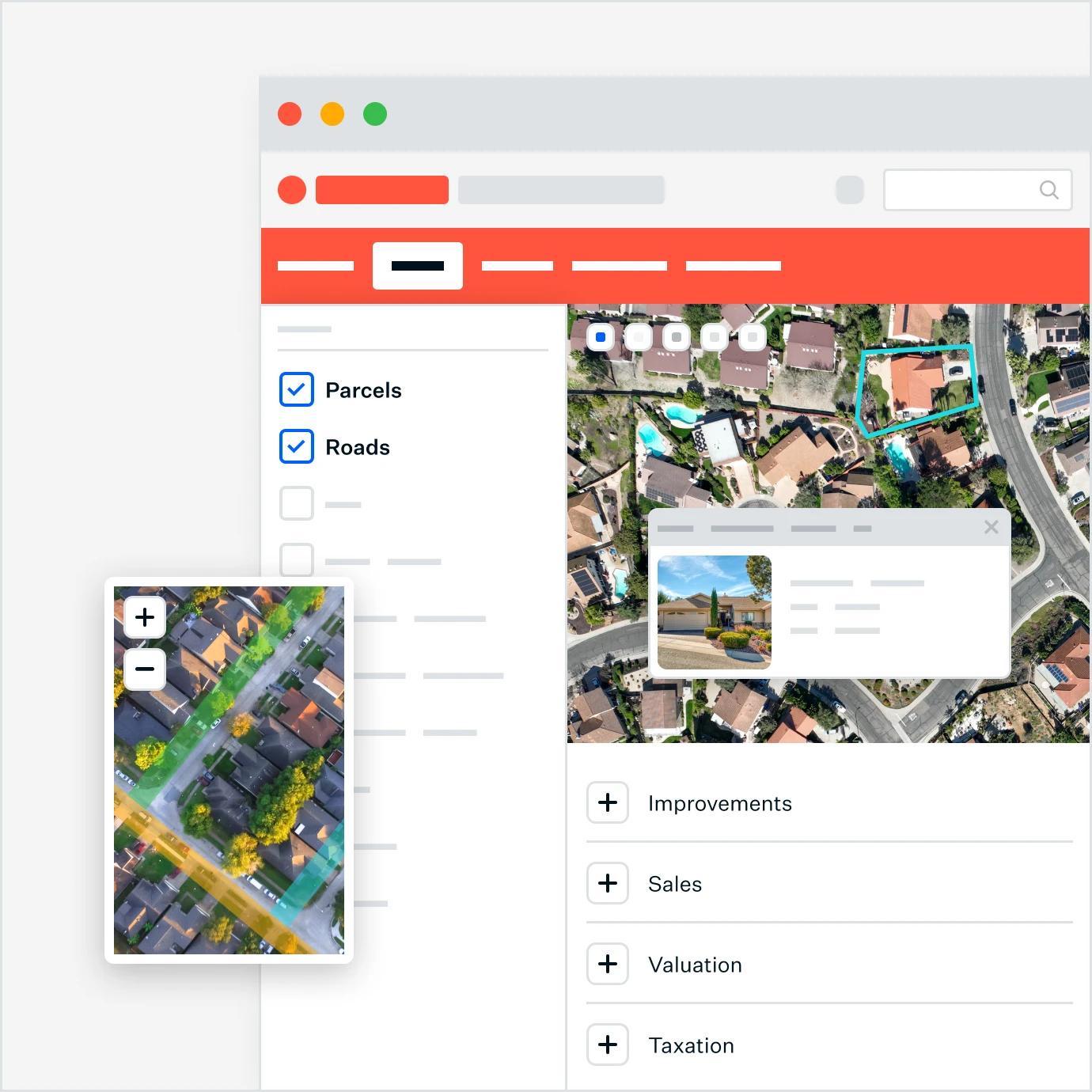
An interactive web-based GIS platform interface showing parcel and property data over satellite imagery, with features like selectable map layers (Parcels, Roads), zoom controls, and detailed property information cards, designed to help users seamlessly compile and analyze geographic and tax-related data.
Visualize​​​​‌‍​‍​‍‌‍‌​‍‌‍‍‌‌‍‌‌‍‍‌‌‍‍​‍​‍​‍‍​‍​‍‌​‌‍​‌‌‍‍‌‍‍‌‌‌​‌‍‌​‍‍‌‍‍‌‌‍​‍​‍​‍​​‍​‍‌‍‍​‌​‍‌‍‌‌‌‍‌‍​‍​‍​‍‍​‍​‍‌‍‍​‌‌​‌‌​‌​​​‍‍​‍​‍‌‍​‌‍‌‍​‌‍​‌‌‍​‌‍‍​‌‍‌​‌‌​​‍‍​​​​​​​​​‍‌‍‍‌‌‍‍‌‌​‌‍‌‌‌‍‍‌‌​​‍‌‍‌‌‌‍‌​‌‍‍‌‌‌​​‍‌‍‌‌‍‌‍‌​‌‍‌‌​‌‌​​‌​‍‌‍‌‌‌​‌‍‌‌‌‍‍‌‌​‌‍​‌‌‌​‌‍‍‌‌‍‌‍‍​‍‌‍‍‌‌‍‌​​‌‌​​‌‍​‌‌​‍‌‍​‌‍‌‌‌‍​‌‌​​‌‍​‌‌‍‌‌‍‌‌​‍‌‌​‌‍‌‌​​‌‍‌‌​‌‌​​‌‍​‌‌​‍‌‍​‌‍‌‌‌‍​‌‌​​‌‍​‌‌‍‌‌‍‌‌​‍‌​​‌‍​‌‌‌​‌‍‍​​‌‌​‌‍‌‍​‌‌‌‌‌​‌‍‍‌‌‍‌‍‍‌‌​‌‍‌‌‌‍​‌‌​‌‍‍‌‌‍‌‍‍‌​​‍‌‌​‌‌‌​​‍‌‌‌‍‍‌‍‌‌‌‍‌​‍‌‌​​‌​‌​​‍‌‌​​‌​‌​​‍‌‌​​‍​​‍‌‍​‍​‍​‌‍‌​‌‍​‍‌‍‌‍‌‍‌‌​‍​​‌‌​‌‍​‍​​​​‌​‍‌‌​​‍​​‍​‍‌‌​‌‌‌​‌​​‍‍‌‌​‌‍‍‌‌‌​‌‍​‌‍‌‌​‌‍​‍‌‍​‌‌​‌‍‌‌‌‌‌‌‌​‍‌‍​​‌‌‍‍​‌‌​‌‌​‌​​​‍‌‌​​‌​​‌​‍‌‌​​‍‌​‌‍​‍‌‌​​‍‌​‌‍‌‍​‌‍‌‍​‌‍​‌‌‍​‌‍‍​‌‍‌​‌‌​​‍‌‌​​‌​​‌​​​​​​​​​‍‌‍‌‍‍‌‌‍‌​​‌‌​​‌‍​‌‌​‍‌‍​‌‍‌‌‌‍​‌‌​​‌‍​‌‌‍‌‌‍‌‌​‍‌‍‌‌​‌‍‌‌​​‌‍‌‌​‌‌​​‌‍​‌‌​‍‌‍​‌‍‌‌‌‍​‌‌​​‌‍​‌‌‍‌‌‍‌‌​‍‌‍‌​​‌‍​‌‌‌​‌‍‍​​‌‌​‌‍‌‍​‌‌‌‌‌​‌‍‍‌‌‍‌‍‍‌‌​‌‍‌‌‌‍​‌‌​‌‍‍‌‌‍‌‍‍‌​​‍‌‌​‌‌‌​​‍‌‌‌‍‍‌‍‌‌‌‍‌​‍‌‌​​‌​‌​​‍‌‌​​‌​‌​​‍‌‌​​‍​​‍‌‍​‍​‍​‌‍‌​‌‍​‍‌‍‌‍‌‍‌‌​‍​​‌‌​‌‍​‍​​​​‌​‍‌‌​​‍​​‍​‍‌‌​‌‌‌​‌​​‍‍‌‌​‌‍‍‌‌‌​‌‍​‌‍‌‌​‍​‍‌‌

MAP DATA​​​​‌‍​‍​‍‌‍‌​‍‌‍‍‌‌‍‌‌‍‍‌‌‍‍​‍​‍​‍‍​‍​‍‌​‌‍​‌‌‍‍‌‍‍‌‌‌​‌‍‌​‍‍‌‍‍‌‌‍​‍​‍​‍​​‍​‍‌‍‍​‌​‍‌‍‌‌‌‍‌‍​‍​‍​‍‍​‍​‍‌‍‍​‌‌​‌‌​‌​​​‍‍​‍​‍‌‍​‌‍‌‍​‌‍​‌‌‍​‌‍‍​‌‍‌​‌‌​​‍‍​​​​​​​​​‍‌‍‍‌‌‍‍‌‌​‌‍‌‌‌‍‍‌‌​​‍‌‍‌‌‌‍‌​‌‍‍‌‌‌​​‍‌‍‌‌‍‌‍‌​‌‍‌‌​‌‌​​‌​‍‌‍‌‌‌​‌‍‌‌‌‍‍‌‌​‌‍​‌‌‌​‌‍‍‌‌‍‌‍‍​‍‌‍‍‌‌‍‌​​‌‌​​‌‍​‌‌​‍‌‍​‌‍‌‌‌‍​‌‌​​‌‍​‌‌‍‌‌‍‌‌​‍‌‌​‌‍‌‌​​‌‍‌‌​‌‌​​‌‍​‌‌​‍‌‍​‌‍‌‌‌‍​‌‌​​‌‍​‌‌‍‌‌‍‌‌​‍‌​​‌‍​‌‌‌​‌‍‍​​‌‌​‌‍‌‍​‌‌‌‌‌​‌‍‍‌‌‍‌‍‍‌‌​‌‍‌‌‌‍​‌‌​‌‍‍‌‌‍‌‍‍‌​​‍‌‌​‌‌‌​​‍‌‌‌‍‍‌‍‌‌‌‍‌​‍‌‌​​‌​‌​​‍‌‌​​‌​‌​​‍‌‌​​‍​​‍‌‍​‍​‍​‌‍‌​‌‍​‍‌‍‌‍‌‍‌‌​‍​​‌‌​‌‍​‍​​​​‌​‍‌‌​​‍​​‍​‍‌‌​‌‌‌​‌​​‍‍‌‌​‌‍​‌‌‍‌‌‌​‌‍‍‌‌‌​‌‍​‌‍‌‌​‌‍​‍‌‍​‌‌​‌‍‌‌‌‌‌‌‌​‍‌‍​​‌‌‍‍​‌‌​‌‌​‌​​​‍‌‌​​‌​​‌​‍‌‌​​‍‌​‌‍​‍‌‌​​‍‌​‌‍‌‍​‌‍‌‍​‌‍​‌‌‍​‌‍‍​‌‍‌​‌‌​​‍‌‌​​‌​​‌​​​​​​​​​‍‌‍‌‍‍‌‌‍‌​​‌‌​​‌‍​‌‌​‍‌‍​‌‍‌‌‌‍​‌‌​​‌‍​‌‌‍‌‌‍‌‌​‍‌‍‌‌​‌‍‌‌​​‌‍‌‌​‌‌​​‌‍​‌‌​‍‌‍​‌‍‌‌‌‍​‌‌​​‌‍​‌‌‍‌‌‍‌‌​‍‌‍‌​​‌‍​‌‌‌​‌‍‍​​‌‌​‌‍‌‍​‌‌‌‌‌​‌‍‍‌‌‍‌‍‍‌‌​‌‍‌‌‌‍​‌‌​‌‍‍‌‌‍‌‍‍‌​​‍‌‌​‌‌‌​​‍‌‌‌‍‍‌‍‌‌‌‍‌​‍‌‌​​‌​‌​​‍‌‌​​‌​‌​​‍‌‌​​‍​​‍‌‍​‍​‍​‌‍‌​‌‍​‍‌‍‌‍‌‍‌‌​‍​​‌‌​‌‍​‍​​​​‌​‍‌‌​​‍​​‍​‍‌‌​‌‌‌​‌​​‍‍‌‌​‌‍​‌‌‍‌‌‌​‌‍‍‌‌‌​‌‍​‌‍‌‌​‍​‍‌‌

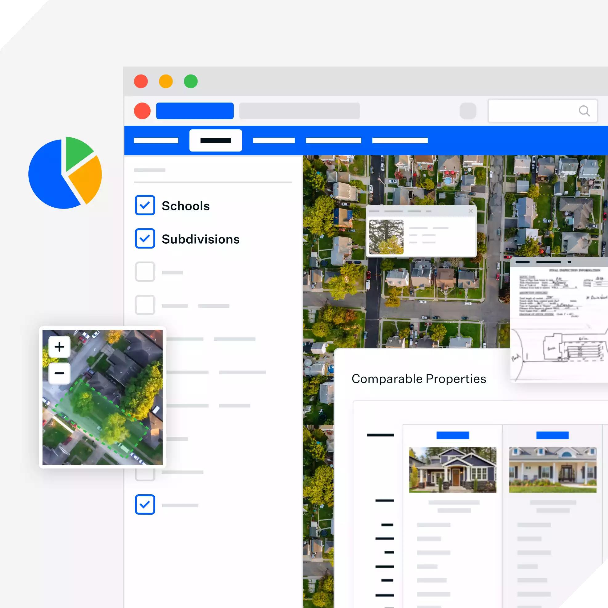
Use map data to improve insights​​​​‌‍​‍​‍‌‍‌​‍‌‍‍‌‌‍‌‌‍‍‌‌‍‍​‍​‍​‍‍​‍​‍‌​‌‍​‌‌‍‍‌‍‍‌‌‌​‌‍‌​‍‍‌‍‍‌‌‍​‍​‍​‍​​‍​‍‌‍‍​‌​‍‌‍‌‌‌‍‌‍​‍​‍​‍‍​‍​‍‌‍‍​‌‌​‌‌​‌​​​‍‍​‍​‍‌‍​‌‍‌‍​‌‍​‌‌‍​‌‍‍​‌‍‌​‌‌​​‍‍​​​​​​​​​‍‌‍‍‌‌‍‍‌‌​‌‍‌‌‌‍‍‌‌​​‍‌‍‌‌‌‍‌​‌‍‍‌‌‌​​‍‌‍‌‌‍‌‍‌​‌‍‌‌​‌‌​​‌​‍‌‍‌‌‌​‌‍‌‌‌‍‍‌‌​‌‍​‌‌‌​‌‍‍‌‌‍‌‍‍​‍‌‍‍‌‌‍‌​​‌‌​​‌‍​‌‌​‍‌‍​‌‍‌‌‌‍​‌‌​​‌‍​‌‌‍‌‌‍‌‌​‍‌‌​‌‍‌‌​​‌‍‌‌​‌‌​​‌‍​‌‌​‍‌‍​‌‍‌‌‌‍​‌‌​​‌‍​‌‌‍‌‌‍‌‌​‍‌​​‌‍​‌‌‌​‌‍‍​​‌‌​‌‍‌‍​‌‌‌‌‌​‌‍‍‌‌‍‌‍‍‌‌​‌‍‌‌‌‍​‌‌​‌‍‍‌‌‍‌‍‍‌​​‍‌‌​‌‌‌​​‍‌‌‌‍‍‌‍‌‌‌‍‌​‍‌‌​​‌​‌​​‍‌‌​​‌​‌​​‍‌‌​​‍​​‍‌‍​‍​‍​‌‍‌​‌‍​‍‌‍‌‍‌‍‌‌​‍​​‌‌​‌‍​‍​​​​‌​‍‌‌​​‍​​‍​‍‌‌​‌‌‌​‌​​‍‍‌​‌‌‌‌‍​‍‌‌​‌‍‍‌‌‌​‌‍​‌‍‌‌​‌‍​‍‌‍​‌‌​‌‍‌‌‌‌‌‌‌​‍‌‍​​‌‌‍‍​‌‌​‌‌​‌​​​‍‌‌​​‌​​‌​‍‌‌​​‍‌​‌‍​‍‌‌​​‍‌​‌‍‌‍​‌‍‌‍​‌‍​‌‌‍​‌‍‍​‌‍‌​‌‌​​‍‌‌​​‌​​‌​​​​​​​​​‍‌‍‌‍‍‌‌‍‌​​‌‌​​‌‍​‌‌​‍‌‍​‌‍‌‌‌‍​‌‌​​‌‍​‌‌‍‌‌‍‌‌​‍‌‍‌‌​‌‍‌‌​​‌‍‌‌​‌‌​​‌‍​‌‌​‍‌‍​‌‍‌‌‌‍​‌‌​​‌‍​‌‌‍‌‌‍‌‌​‍‌‍‌​​‌‍​‌‌‌​‌‍‍​​‌‌​‌‍‌‍​‌‌‌‌‌​‌‍‍‌‌‍‌‍‍‌‌​‌‍‌‌‌‍​‌‌​‌‍‍‌‌‍‌‍‍‌​​‍‌‌​‌‌‌​​‍‌‌‌‍‍‌‍‌‌‌‍‌​‍‌‌​​‌​‌​​‍‌‌​​‌​‌​​‍‌‌​​‍​​‍‌‍​‍​‍​‌‍‌​‌‍​‍‌‍‌‍‌‍‌‌​‍​​‌‌​‌‍​‍​​​​‌​‍‌‌​​‍​​‍​‍‌‌​‌‌‌​‌​​‍‍‌​‌‌‌‌‍​‍‌‌​‌‍‍‌‌‌​‌‍​‌‍‌‌​‍​‍‌‌


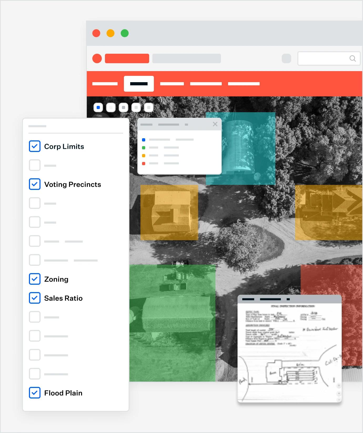
A GIS platform interface displaying layered map data with color-coded overlays for features like corporate limits, voting precincts, zoning, sales ratio, and flood plain. The interface includes toggleable checkboxes for each layer and pop-up windows showing detailed data and scanned documents, enabling users to improve insights through visual analysis of geographic and planning data.
Analyze​​​​‌‍​‍​‍‌‍‌​‍‌‍‍‌‌‍‌‌‍‍‌‌‍‍​‍​‍​‍‍​‍​‍‌​‌‍​‌‌‍‍‌‍‍‌‌‌​‌‍‌​‍‍‌‍‍‌‌‍​‍​‍​‍​​‍​‍‌‍‍​‌​‍‌‍‌‌‌‍‌‍​‍​‍​‍‍​‍​‍‌‍‍​‌‌​‌‌​‌​​​‍‍​‍​‍‌‍​‌‍‌‍​‌‍​‌‌‍​‌‍‍​‌‍‌​‌‌​​‍‍​​​​​​​​​‍‌‍‍‌‌‍‍‌‌​‌‍‌‌‌‍‍‌‌​​‍‌‍‌‌‌‍‌​‌‍‍‌‌‌​​‍‌‍‌‌‍‌‍‌​‌‍‌‌​‌‌​​‌​‍‌‍‌‌‌​‌‍‌‌‌‍‍‌‌​‌‍​‌‌‌​‌‍‍‌‌‍‌‍‍​‍‌‍‍‌‌‍‌​​‌‌​​‌‍​‌‌​‍‌‍​‌‍‌‌‌‍​‌‌​​‌‍​‌‌‍‌‌‍‌‌​‍‌‌​‌‍‌‌​​‌‍‌‌​‌‌​​‌‍​‌‌​‍‌‍​‌‍‌‌‌‍​‌‌​​‌‍​‌‌‍‌‌‍‌‌​‍‌​​‌‍​‌‌‌​‌‍‍​​‌‌​‌‍‌‍​‌‌‌‌‌​‌‍‍‌‌‍‌‍‍‌‌​‌‍‌‌‌‍​‌‌​‌‍‍‌‌‍‌‍‍‌​​‍‌‌​‌‌‌​​‍‌‌‌‍‍‌‍‌‌‌‍‌​‍‌‌​​‌​‌​​‍‌‌​​‌​‌​​‍‌‌​​‍​​‍‌‍​​​‍‌‍​‍​​‌‌‍​‍​‌​​‌‌‍‌​‌‍​​‌‌‍​​‌‌​‍‌‌​​‍​​‍​‍‌‌​‌‌‌​‌​​‍‍‌‌​‌‍‍‌‌‌​‌‍​‌‍‌‌​‌‍​‍‌‍​‌‌​‌‍‌‌‌‌‌‌‌​‍‌‍​​‌‌‍‍​‌‌​‌‌​‌​​​‍‌‌​​‌​​‌​‍‌‌​​‍‌​‌‍​‍‌‌​​‍‌​‌‍‌‍​‌‍‌‍​‌‍​‌‌‍​‌‍‍​‌‍‌​‌‌​​‍‌‌​​‌​​‌​​​​​​​​​‍‌‍‌‍‍‌‌‍‌​​‌‌​​‌‍​‌‌​‍‌‍​‌‍‌‌‌‍​‌‌​​‌‍​‌‌‍‌‌‍‌‌​‍‌‍‌‌​‌‍‌‌​​‌‍‌‌​‌‌​​‌‍​‌‌​‍‌‍​‌‍‌‌‌‍​‌‌​​‌‍​‌‌‍‌‌‍‌‌​‍‌‍‌​​‌‍​‌‌‌​‌‍‍​​‌‌​‌‍‌‍​‌‌‌‌‌​‌‍‍‌‌‍‌‍‍‌‌​‌‍‌‌‌‍​‌‌​‌‍‍‌‌‍‌‍‍‌​​‍‌‌​‌‌‌​​‍‌‌‌‍‍‌‍‌‌‌‍‌​‍‌‌​​‌​‌​​‍‌‌​​‌​‌​​‍‌‌​​‍​​‍‌‍​​​‍‌‍​‍​​‌‌‍​‍​‌​​‌‌‍‌​‌‍​​‌‌‍​​‌‌​‍‌‌​​‍​​‍​‍‌‌​‌‌‌​‌​​‍‍‌‌​‌‍‍‌‌‌​‌‍​‌‍‌‌​‍​‍‌‌

STANDARDIZE + ACCELERATE​​​​‌‍​‍​‍‌‍‌​‍‌‍‍‌‌‍‌‌‍‍‌‌‍‍​‍​‍​‍‍​‍​‍‌​‌‍​‌‌‍‍‌‍‍‌‌‌​‌‍‌​‍‍‌‍‍‌‌‍​‍​‍​‍​​‍​‍‌‍‍​‌​‍‌‍‌‌‌‍‌‍​‍​‍​‍‍​‍​‍‌‍‍​‌‌​‌‌​‌​​​‍‍​‍​‍‌‍​‌‍‌‍​‌‍​‌‌‍​‌‍‍​‌‍‌​‌‌​​‍‍​​​​​​​​​‍‌‍‍‌‌‍‍‌‌​‌‍‌‌‌‍‍‌‌​​‍‌‍‌‌‌‍‌​‌‍‍‌‌‌​​‍‌‍‌‌‍‌‍‌​‌‍‌‌​‌‌​​‌​‍‌‍‌‌‌​‌‍‌‌‌‍‍‌‌​‌‍​‌‌‌​‌‍‍‌‌‍‌‍‍​‍‌‍‍‌‌‍‌​​‌‌​​‌‍​‌‌​‍‌‍​‌‍‌‌‌‍​‌‌​​‌‍​‌‌‍‌‌‍‌‌​‍‌‌​‌‍‌‌​​‌‍‌‌​‌‌​​‌‍​‌‌​‍‌‍​‌‍‌‌‌‍​‌‌​​‌‍​‌‌‍‌‌‍‌‌​‍‌​​‌‍​‌‌‌​‌‍‍​​‌‌​‌‍‌‍​‌‌‌‌‌​‌‍‍‌‌‍‌‍‍‌‌​‌‍‌‌‌‍​‌‌​‌‍‍‌‌‍‌‍‍‌​​‍‌‌​‌‌‌​​‍‌‌‌‍‍‌‍‌‌‌‍‌​‍‌‌​​‌​‌​​‍‌‌​​‌​‌​​‍‌‌​​‍​​‍‌‍​​​‍‌‍​‍​​‌‌‍​‍​‌​​‌‌‍‌​‌‍​​‌‌‍​​‌‌​‍‌‌​​‍​​‍​‍‌‌​‌‌‌​‌​​‍‍‌‌​‌‍​‌‌‍‌‌‌​‌‍‍‌‌‌​‌‍​‌‍‌‌​‌‍​‍‌‍​‌‌​‌‍‌‌‌‌‌‌‌​‍‌‍​​‌‌‍‍​‌‌​‌‌​‌​​​‍‌‌​​‌​​‌​‍‌‌​​‍‌​‌‍​‍‌‌​​‍‌​‌‍‌‍​‌‍‌‍​‌‍​‌‌‍​‌‍‍​‌‍‌​‌‌​​‍‌‌​​‌​​‌​​​​​​​​​‍‌‍‌‍‍‌‌‍‌​​‌‌​​‌‍​‌‌​‍‌‍​‌‍‌‌‌‍​‌‌​​‌‍​‌‌‍‌‌‍‌‌​‍‌‍‌‌​‌‍‌‌​​‌‍‌‌​‌‌​​‌‍​‌‌​‍‌‍​‌‍‌‌‌‍​‌‌​​‌‍​‌‌‍‌‌‍‌‌​‍‌‍‌​​‌‍​‌‌‌​‌‍‍​​‌‌​‌‍‌‍​‌‌‌‌‌​‌‍‍‌‌‍‌‍‍‌‌​‌‍‌‌‌‍​‌‌​‌‍‍‌‌‍‌‍‍‌​​‍‌‌​‌‌‌​​‍‌‌‌‍‍‌‍‌‌‌‍‌​‍‌‌​​‌​‌​​‍‌‌​​‌​‌​​‍‌‌​​‍​​‍‌‍​​​‍‌‍​‍​​‌‌‍​‍​‌​​‌‌‍‌​‌‍​​‌‌‍​​‌‌​‍‌‌​​‍​​‍​‍‌‌​‌‌‌​‌​​‍‍‌‌​‌‍​‌‌‍‌‌‌​‌‍‍‌‌‌​‌‍​‌‍‌‌​‍​‍‌‌

Leverage Your Data for Enhanced Citizen Experiences​​​​‌‍​‍​‍‌‍‌​‍‌‍‍‌‌‍‌‌‍‍‌‌‍‍​‍​‍​‍‍​‍​‍‌​‌‍​‌‌‍‍‌‍‍‌‌‌​‌‍‌​‍‍‌‍‍‌‌‍​‍​‍​‍​​‍​‍‌‍‍​‌​‍‌‍‌‌‌‍‌‍​‍​‍​‍‍​‍​‍‌‍‍​‌‌​‌‌​‌​​​‍‍​‍​‍‌‍​‌‍‌‍​‌‍​‌‌‍​‌‍‍​‌‍‌​‌‌​​‍‍​​​​​​​​​‍‌‍‍‌‌‍‍‌‌​‌‍‌‌‌‍‍‌‌​​‍‌‍‌‌‌‍‌​‌‍‍‌‌‌​​‍‌‍‌‌‍‌‍‌​‌‍‌‌​‌‌​​‌​‍‌‍‌‌‌​‌‍‌‌‌‍‍‌‌​‌‍​‌‌‌​‌‍‍‌‌‍‌‍‍​‍‌‍‍‌‌‍‌​​‌‌​​‌‍​‌‌​‍‌‍​‌‍‌‌‌‍​‌‌​​‌‍​‌‌‍‌‌‍‌‌​‍‌‌​‌‍‌‌​​‌‍‌‌​‌‌​​‌‍​‌‌​‍‌‍​‌‍‌‌‌‍​‌‌​​‌‍​‌‌‍‌‌‍‌‌​‍‌​​‌‍​‌‌‌​‌‍‍​​‌‌​‌‍‌‍​‌‌‌‌‌​‌‍‍‌‌‍‌‍‍‌‌​‌‍‌‌‌‍​‌‌​‌‍‍‌‌‍‌‍‍‌​​‍‌‌​‌‌‌​​‍‌‌‌‍‍‌‍‌‌‌‍‌​‍‌‌​​‌​‌​​‍‌‌​​‌​‌​​‍‌‌​​‍​​‍‌‍​​​‍‌‍​‍​​‌‌‍​‍​‌​​‌‌‍‌​‌‍​​‌‌‍​​‌‌​‍‌‌​​‍​​‍​‍‌‌​‌‌‌​‌​​‍‍‌​‌‌‌‌‍​‍‌‌​‌‍‍‌‌‌​‌‍​‌‍‌‌​‌‍​‍‌‍​‌‌​‌‍‌‌‌‌‌‌‌​‍‌‍​​‌‌‍‍​‌‌​‌‌​‌​​​‍‌‌​​‌​​‌​‍‌‌​​‍‌​‌‍​‍‌‌​​‍‌​‌‍‌‍​‌‍‌‍​‌‍​‌‌‍​‌‍‍​‌‍‌​‌‌​​‍‌‌​​‌​​‌​​​​​​​​​‍‌‍‌‍‍‌‌‍‌​​‌‌​​‌‍​‌‌​‍‌‍​‌‍‌‌‌‍​‌‌​​‌‍​‌‌‍‌‌‍‌‌​‍‌‍‌‌​‌‍‌‌​​‌‍‌‌​‌‌​​‌‍​‌‌​‍‌‍​‌‍‌‌‌‍​‌‌​​‌‍​‌‌‍‌‌‍‌‌​‍‌‍‌​​‌‍​‌‌‌​‌‍‍​​‌‌​‌‍‌‍​‌‌‌‌‌​‌‍‍‌‌‍‌‍‍‌‌​‌‍‌‌‌‍​‌‌​‌‍‍‌‌‍‌‍‍‌​​‍‌‌​‌‌‌​​‍‌‌‌‍‍‌‍‌‌‌‍‌​‍‌‌​​‌​‌​​‍‌‌​​‌​‌​​‍‌‌​​‍​​‍‌‍​​​‍‌‍​‍​​‌‌‍​‍​‌​​‌‌‍‌​‌‍​​‌‌‍​​‌‌​‍‌‌​​‍​​‍​‍‌‌​‌‌‌​‌​​‍‍‌​‌‌‌‌‍​‍‌‌​‌‍‍‌‌‌​‌‍​‌‍‌‌​‍​‍‌‌


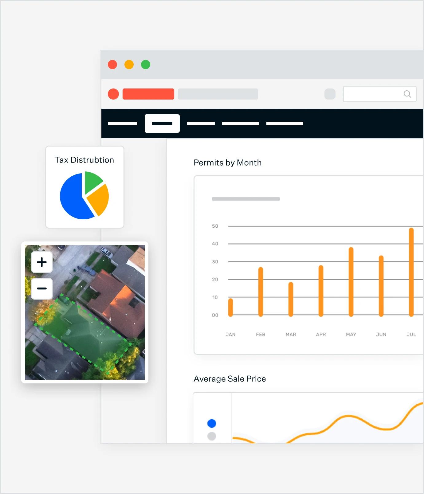
A Schneider GIS dashboard showing a map with a highlighted property, a 'Tax Distribution' pie chart, a 'Permits by Month' bar graph, and 'Average Sale Price' line graph.
Engage​​​​‌‍​‍​‍‌‍‌​‍‌‍‍‌‌‍‌‌‍‍‌‌‍‍​‍​‍​‍‍​‍​‍‌​‌‍​‌‌‍‍‌‍‍‌‌‌​‌‍‌​‍‍‌‍‍‌‌‍​‍​‍​‍​​‍​‍‌‍‍​‌​‍‌‍‌‌‌‍‌‍​‍​‍​‍‍​‍​‍‌‍‍​‌‌​‌‌​‌​​​‍‍​‍​‍‌‍​‌‍‌‍​‌‍​‌‌‍​‌‍‍​‌‍‌​‌‌​​‍‍​​​​​​​​​‍‌‍‍‌‌‍‍‌‌​‌‍‌‌‌‍‍‌‌​​‍‌‍‌‌‌‍‌​‌‍‍‌‌‌​​‍‌‍‌‌‍‌‍‌​‌‍‌‌​‌‌​​‌​‍‌‍‌‌‌​‌‍‌‌‌‍‍‌‌​‌‍​‌‌‌​‌‍‍‌‌‍‌‍‍​‍‌‍‍‌‌‍‌​​‌‌​​‌‍​‌‌​‍‌‍​‌‍‌‌‌‍​‌‌​​‌‍​‌‌‍‌‌‍‌‌​‍‌‌​‌‍‌‌​​‌‍‌‌​‌‌​​‌‍​‌‌​‍‌‍​‌‍‌‌‌‍​‌‌​​‌‍​‌‌‍‌‌‍‌‌​‍‌​​‌‍​‌‌‌​‌‍‍​​‌‌​‌‍‌‍​‌‌‌‌‌​‌‍‍‌‌‍‌‍‍‌‌​‌‍‌‌‌‍​‌‌​‌‍‍‌‌‍‌‍‍‌​​‍‌‌​‌‌‌​​‍‌‌‌‍‍‌‍‌‌‌‍‌​‍‌‌​​‌​‌​​‍‌‌​​‌​‌​​‍‌‌​​‍​​‍​‌‌​‌‍‌‍​‌‍‌‌​​​‍​​​‌‌‍‌‍‌‍‌‌‌‍‌‌‌‍​​​‍​‍‌‌​​‍​​‍​‍‌‌​‌‌‌​‌​​‍‍‌‌​‌‍‍‌‌‌​‌‍​‌‍‌‌​‌‍​‍‌‍​‌‌​‌‍‌‌‌‌‌‌‌​‍‌‍​​‌‌‍‍​‌‌​‌‌​‌​​​‍‌‌​​‌​​‌​‍‌‌​​‍‌​‌‍​‍‌‌​​‍‌​‌‍‌‍​‌‍‌‍​‌‍​‌‌‍​‌‍‍​‌‍‌​‌‌​​‍‌‌​​‌​​‌​​​​​​​​​‍‌‍‌‍‍‌‌‍‌​​‌‌​​‌‍​‌‌​‍‌‍​‌‍‌‌‌‍​‌‌​​‌‍​‌‌‍‌‌‍‌‌​‍‌‍‌‌​‌‍‌‌​​‌‍‌‌​‌‌​​‌‍​‌‌​‍‌‍​‌‍‌‌‌‍​‌‌​​‌‍​‌‌‍‌‌‍‌‌​‍‌‍‌​​‌‍​‌‌‌​‌‍‍​​‌‌​‌‍‌‍​‌‌‌‌‌​‌‍‍‌‌‍‌‍‍‌‌​‌‍‌‌‌‍​‌‌​‌‍‍‌‌‍‌‍‍‌​​‍‌‌​‌‌‌​​‍‌‌‌‍‍‌‍‌‌‌‍‌​‍‌‌​​‌​‌​​‍‌‌​​‌​‌​​‍‌‌​​‍​​‍​‌‌​‌‍‌‍​‌‍‌‌​​​‍​​​‌‌‍‌‍‌‍‌‌‌‍‌‌‌‍​​​‍​‍‌‌​​‍​​‍​‍‌‌​‌‌‌​‌​​‍‍‌‌​‌‍‍‌‌‌​‌‍​‌‍‌‌​‍​‍‌‌

EMPOWER CITIZENS​​​​‌‍​‍​‍‌‍‌​‍‌‍‍‌‌‍‌‌‍‍‌‌‍‍​‍​‍​‍‍​‍​‍‌​‌‍​‌‌‍‍‌‍‍‌‌‌​‌‍‌​‍‍‌‍‍‌‌‍​‍​‍​‍​​‍​‍‌‍‍​‌​‍‌‍‌‌‌‍‌‍​‍​‍​‍‍​‍​‍‌‍‍​‌‌​‌‌​‌​​​‍‍​‍​‍‌‍​‌‍‌‍​‌‍​‌‌‍​‌‍‍​‌‍‌​‌‌​​‍‍​​​​​​​​​‍‌‍‍‌‌‍‍‌‌​‌‍‌‌‌‍‍‌‌​​‍‌‍‌‌‌‍‌​‌‍‍‌‌‌​​‍‌‍‌‌‍‌‍‌​‌‍‌‌​‌‌​​‌​‍‌‍‌‌‌​‌‍‌‌‌‍‍‌‌​‌‍​‌‌‌​‌‍‍‌‌‍‌‍‍​‍‌‍‍‌‌‍‌​​‌‌​​‌‍​‌‌​‍‌‍​‌‍‌‌‌‍​‌‌​​‌‍​‌‌‍‌‌‍‌‌​‍‌‌​‌‍‌‌​​‌‍‌‌​‌‌​​‌‍​‌‌​‍‌‍​‌‍‌‌‌‍​‌‌​​‌‍​‌‌‍‌‌‍‌‌​‍‌​​‌‍​‌‌‌​‌‍‍​​‌‌​‌‍‌‍​‌‌‌‌‌​‌‍‍‌‌‍‌‍‍‌‌​‌‍‌‌‌‍​‌‌​‌‍‍‌‌‍‌‍‍‌​​‍‌‌​‌‌‌​​‍‌‌‌‍‍‌‍‌‌‌‍‌​‍‌‌​​‌​‌​​‍‌‌​​‌​‌​​‍‌‌​​‍​​‍​‌‌​‌‍‌‍​‌‍‌‌​​​‍​​​‌‌‍‌‍‌‍‌‌‌‍‌‌‌‍​​​‍​‍‌‌​​‍​​‍​‍‌‌​‌‌‌​‌​​‍‍‌‌​‌‍​‌‌‍‌‌‌​‌‍‍‌‌‌​‌‍​‌‍‌‌​‌‍​‍‌‍​‌‌​‌‍‌‌‌‌‌‌‌​‍‌‍​​‌‌‍‍​‌‌​‌‌​‌​​​‍‌‌​​‌​​‌​‍‌‌​​‍‌​‌‍​‍‌‌​​‍‌​‌‍‌‍​‌‍‌‍​‌‍​‌‌‍​‌‍‍​‌‍‌​‌‌​​‍‌‌​​‌​​‌​​​​​​​​​‍‌‍‌‍‍‌‌‍‌​​‌‌​​‌‍​‌‌​‍‌‍​‌‍‌‌‌‍​‌‌​​‌‍​‌‌‍‌‌‍‌‌​‍‌‍‌‌​‌‍‌‌​​‌‍‌‌​‌‌​​‌‍​‌‌​‍‌‍​‌‍‌‌‌‍​‌‌​​‌‍​‌‌‍‌‌‍‌‌​‍‌‍‌​​‌‍​‌‌‌​‌‍‍​​‌‌​‌‍‌‍​‌‌‌‌‌​‌‍‍‌‌‍‌‍‍‌‌​‌‍‌‌‌‍​‌‌​‌‍‍‌‌‍‌‍‍‌​​‍‌‌​‌‌‌​​‍‌‌‌‍‍‌‍‌‌‌‍‌​‍‌‌​​‌​‌​​‍‌‌​​‌​‌​​‍‌‌​​‍​​‍​‌‌​‌‍‌‍​‌‍‌‌​​​‍​​​‌‌‍‌‍‌‍‌‌‌‍‌‌‌‍​​​‍​‍‌‌​​‍​​‍​‍‌‌​‌‌‌​‌​​‍‍‌‌​‌‍​‌‌‍‌‌‌​‌‍‍‌‌‌​‌‍​‌‍‌‌​‍​‍‌‌

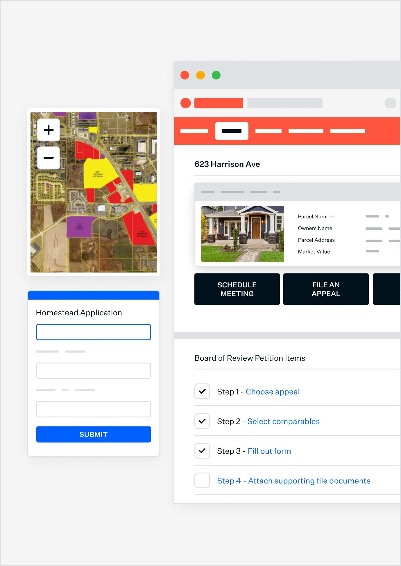
Put parcel data and documentation into taxpayers’ hands​​​​‌‍​‍​‍‌‍‌​‍‌‍‍‌‌‍‌‌‍‍‌‌‍‍​‍​‍​‍‍​‍​‍‌​‌‍​‌‌‍‍‌‍‍‌‌‌​‌‍‌​‍‍‌‍‍‌‌‍​‍​‍​‍​​‍​‍‌‍‍​‌​‍‌‍‌‌‌‍‌‍​‍​‍​‍‍​‍​‍‌‍‍​‌‌​‌‌​‌​​​‍‍​‍​‍‌‍​‌‍‌‍​‌‍​‌‌‍​‌‍‍​‌‍‌​‌‌​​‍‍​​​​​​​​​‍‌‍‍‌‌‍‍‌‌​‌‍‌‌‌‍‍‌‌​​‍‌‍‌‌‌‍‌​‌‍‍‌‌‌​​‍‌‍‌‌‍‌‍‌​‌‍‌‌​‌‌​​‌​‍‌‍‌‌‌​‌‍‌‌‌‍‍‌‌​‌‍​‌‌‌​‌‍‍‌‌‍‌‍‍​‍‌‍‍‌‌‍‌​​‌‌​​‌‍​‌‌​‍‌‍​‌‍‌‌‌‍​‌‌​​‌‍​‌‌‍‌‌‍‌‌​‍‌‌​‌‍‌‌​​‌‍‌‌​‌‌​​‌‍​‌‌​‍‌‍​‌‍‌‌‌‍​‌‌​​‌‍​‌‌‍‌‌‍‌‌​‍‌​​‌‍​‌‌‌​‌‍‍​​‌‌​‌‍‌‍​‌‌‌‌‌​‌‍‍‌‌‍‌‍‍‌‌​‌‍‌‌‌‍​‌‌​‌‍‍‌‌‍‌‍‍‌​​‍‌‌​‌‌‌​​‍‌‌‌‍‍‌‍‌‌‌‍‌​‍‌‌​​‌​‌​​‍‌‌​​‌​‌​​‍‌‌​​‍​​‍​‌‌​‌‍‌‍​‌‍‌‌​​​‍​​​‌‌‍‌‍‌‍‌‌‌‍‌‌‌‍​​​‍​‍‌‌​​‍​​‍​‍‌‌​‌‌‌​‌​​‍‍‌​‌‌‌‌‍​‍‌‌​‌‍‍‌‌‌​‌‍​‌‍‌‌​‌‍​‍‌‍​‌‌​‌‍‌‌‌‌‌‌‌​‍‌‍​​‌‌‍‍​‌‌​‌‌​‌​​​‍‌‌​​‌​​‌​‍‌‌​​‍‌​‌‍​‍‌‌​​‍‌​‌‍‌‍​‌‍‌‍​‌‍​‌‌‍​‌‍‍​‌‍‌​‌‌​​‍‌‌​​‌​​‌​​​​​​​​​‍‌‍‌‍‍‌‌‍‌​​‌‌​​‌‍​‌‌​‍‌‍​‌‍‌‌‌‍​‌‌​​‌‍​‌‌‍‌‌‍‌‌​‍‌‍‌‌​‌‍‌‌​​‌‍‌‌​‌‌​​‌‍​‌‌​‍‌‍​‌‍‌‌‌‍​‌‌​​‌‍​‌‌‍‌‌‍‌‌​‍‌‍‌​​‌‍​‌‌‌​‌‍‍​​‌‌​‌‍‌‍​‌‌‌‌‌​‌‍‍‌‌‍‌‍‍‌‌​‌‍‌‌‌‍​‌‌​‌‍‍‌‌‍‌‍‍‌​​‍‌‌​‌‌‌​​‍‌‌‌‍‍‌‍‌‌‌‍‌​‍‌‌​​‌​‌​​‍‌‌​​‌​‌​​‍‌‌​​‍​​‍​‌‌​‌‍‌‍​‌‍‌‌​​​‍​​​‌‌‍‌‍‌‍‌‌‌‍‌‌‌‍​​​‍​‍‌‌​​‍​​‍​‍‌‌​‌‌‌​‌​​‍‍‌​‌‌‌‌‍​‍‌‌​‌‍‍‌‌‌​‌‍​‌‍‌‌​‍​‍‌‌


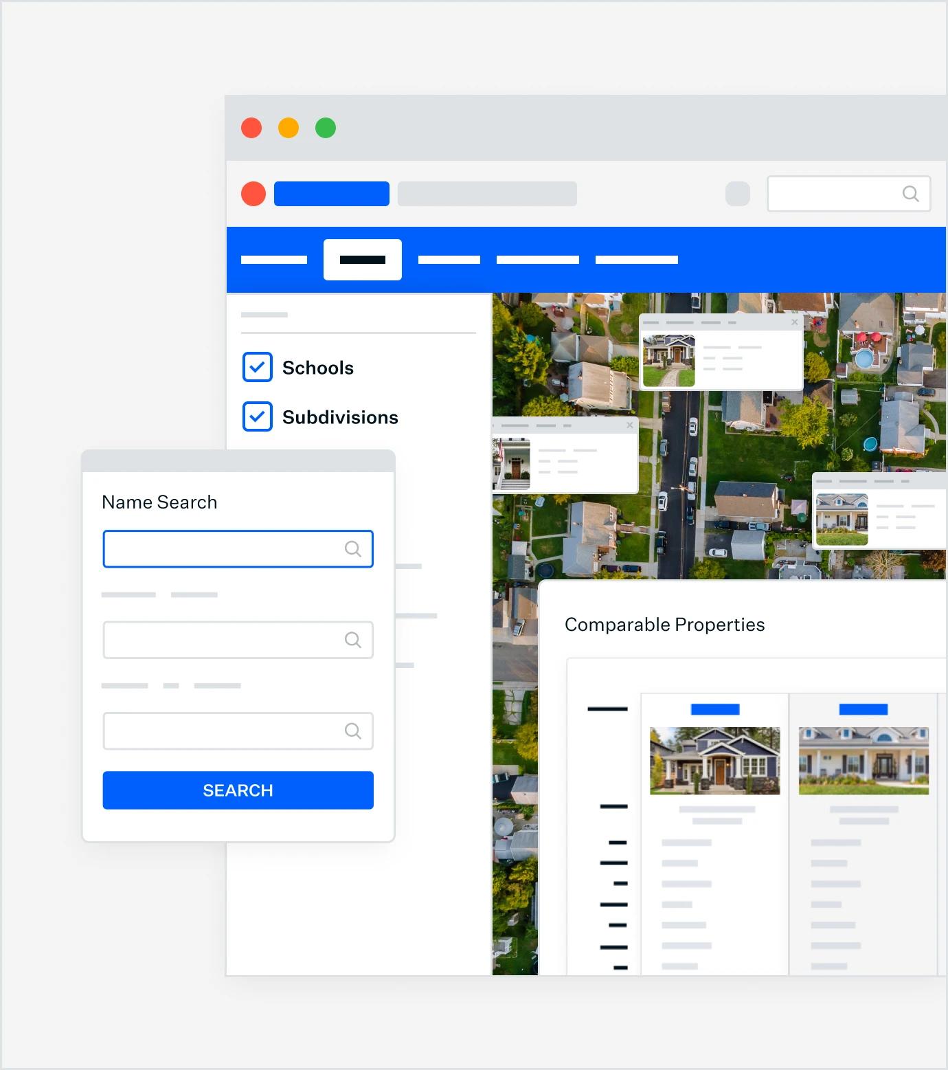
A Schneider GIS interface for taxpayers to access parcel data, apply for homestead, view property details, and file property appeals.

Trusted by 1,000+
local governments

Schedule a 15-minute learning session.

We'll talk with you about best practices for Parcel Management, and the solutions other local governments are using, so you're fully informed.

Schedule now